
search
Rome metro map with attractions
Rome metro map with tourist attractions. Rome metro map with attractions (Lazio - Italy) to print. Rome metro map with attractions (Lazio - Italy) to download. The Metro of Rome only has three lines and is currently the smallest metro system in Europe. Nevertheless, Rome metro reaches the city most important attractions. Starting with the Ottaviano station for the Vatican, St. Peter Basilica, the Vatican Museums (including the Sistine Chapel), St. Angelo Castle as you can see in Rome metro map with attractions. Flaminio Station for Piazza del Popolo, Villa Borghese Park. Spagna station for the beautiful areas of Rome, Piazza di Spagna, the Church of the Trinità dei Monti and Villa Medici. Barberini Station for the Trevi Fountain, the Barberini Museum and the Quirinale Palace.
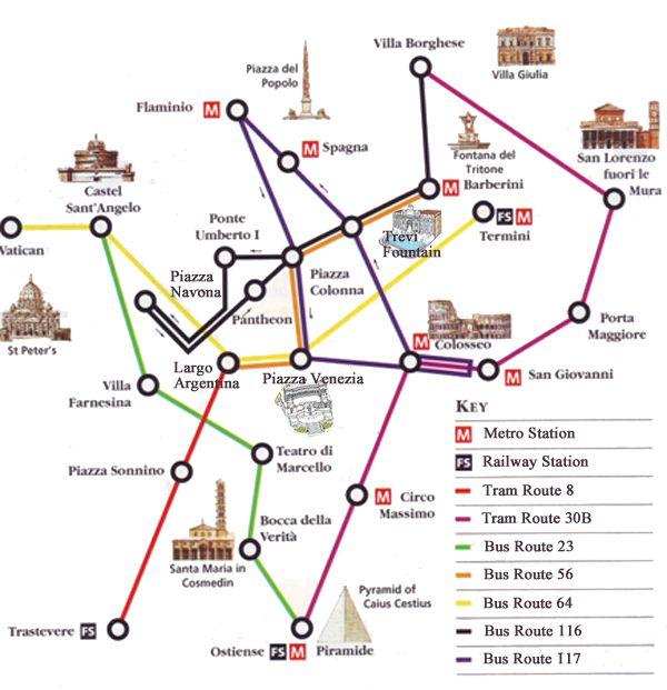
Although the Rome metro only comprises three lines, it gets to most of the city top attractions. These are the most important metro stops to keep in mind: Repubblica Station for the Basilica of Saint Mary of the Angels and Martyrs. Termini Station for the central train station and many cheap accommodations including the majority of youth hostels in Rome as its shown in Rome metro map with attractions. Vittorio Emanuale Station for the National Museum of Asian Art. San Giovanni Station for the Basilica of St. John Lateran. Cinecittà Station for the Cinecittà Cinema City.
Most visitors will only be travelling in a compact area in the centre of Rome where all the main attractions and hotel districts are situated as its mentioned in Rome metro map with attractions. The Rome metro system is very simple, at the moment just 3 lines, only two of which are of use to tourists. If you are planning on using public transport extensively to get around Rome and visit attractions outside the tourist hotspots in the centre then investing in a Rome bus and Metro map is worthwhile.